Recently, the Maharashtra cabinet approved the Wainganga-Nalganga River linking project.
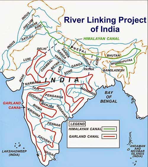
About Interlinking of Rivers
The Indian rivers interlinking project is a proposed large-scale civil engineering project that aims to transfer water from water-surplus regions to water deficient & rain-fed areas through inter-basin transfers, to ensure greater equity in the distribution of water.
The National Water Development Agency has been entrusted with the work of interlinking of rivers under the NPP.
The NPP has two components, viz., Himalayan Rivers Development Component and Peninsular Rivers Development Component.
The National Perspective Plan (NPP) for inter-basin transfer has identified 16 links under the peninsular river’s component and 14 links under the Himalayan component.
The National Perspective Plan was prepared by the then Ministry of Irrigation (now Ministry of Jal Shakti) in 1980.
The Ken-Betwa Link Project is the first inter-linking project taken for implementation as a result of efforts made by the Ministry of Jal Shakti and cooperation of States of Madhya Pradesh and Uttar Pradesh.
Significance of Interlinking of Rivers
Impact on Agriculture: Interlinking rivers can significantly expand irrigation potential, enabling farmers to grow multiple crops and enhancing agricultural productivity. This, in turn, can contribute to food security and rural revitalization
.
Hydropower Generation: The project has the potential to facilitate hydropower production via the utilization of water flow in the linked rivers, meeting the energy demands of the nation while decreasing its dependency on fossil fuels.
Water Transport: Interlinking rivers can facilitate water transport, making it a greener and more cost-effective mode of transportation and reducing the pressure on road and rail infrastructure.
Redistribution of River Water:
Properly planned interlinking projects can be designed to improve river water flow, which may help restore degraded ecosystems and support aquatic biodiversity.
Properly planned interlinking projects can be designed to improve river water flow, which may help restore degraded ecosystems and support aquatic biodiversity.
Addresses Climate Change:
The interconnected river system can help buffer the impact of climate change by managing water resources more effectively and adapting to changing rainfall patterns.
Interconnecting rivers is a holistic and sustainable method of water management that will allow the nation to satisfy the water needs of its fast-expanding population.
Challenges
River water Disputes:
As most rivers in India are inter-state, there have arisen several water disputes regarding the usage of such rivers. The interlinking of rivers would not be prone to such disputes.
The conflicts could emerge in future between donors and recipients States about the former run out of “surplus” water. It is often visible in the ongoing dispute over sharing of the River Cauvery.
Regional Impact: As the Ganga and Brahmaputra are transboundary rivers, India’s proposed engineering of their waters would impact Nepal and Bhutan, where these rivers originate, and Bangladesh, the lower riparian country. It could weaken India’s relations with her neighbour.
Disturbing Monsoon Cycle:The disturbing and irregular monsoon cycles, disturbing complex hydro-meteorological systems, may worsen the water stress across the country, making the interlinking projects ineffective or possibly even counterproductive.
Alterations to the rainfall patterns:
According to the study by Indian Institute of Technology (IIT) Bombay and Indian Institute of Tropical Meteorology, the transfer of water between different basins could disrupt the interactions between land and atmosphere.
This disruption could have an impact on the moisture content of the air and the patterns of wind. These changes, in turn, could result in alterations to the rainfall patterns.
Social- Economic Cost:
The estimated cost of the project is $168 billion. It will take decades to complete, serious cost overruns can be expected.
The construction of canals and reservoirs can result in the displacement of local communities and farmers. This can lead to social conflicts and hardships for the affected people, especially if proper rehabilitation measures are not adopted.
Environmental Cost: :
Environmental shifts, water table ramifications, soil conditions, agricultural patterns, and intrastate and interstate water disputes threaten to destabilize the fragile balance of the country.
Interlinking rivers can cause significant disruptions to natural ecosystems and habitats. It can lead to loss of biodiversity, disruption of aquatic life, and damage to sensitive ecosystems, particularly in the areas where the canals are constructed.
Conclusion
Interlinking rivers is a time-consuming process that involves detailed planning, land acquisition, and environmental clearances.
Failure in implementation can hinder the benefits that the project aims to achieve.
Once canals are constructed and rivers are interconnected, reversing the process becomes highly challenging, making it crucial to thoroughly assess potential adverse impacts before undertaking such projects.
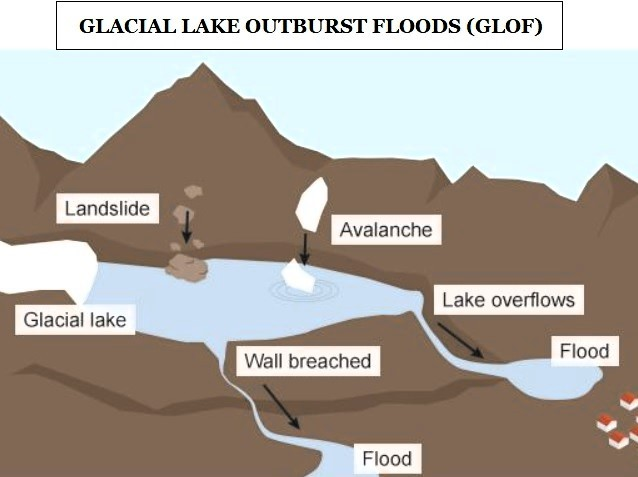
Glacial Lake Outburst Flood
Why in news?
Recently, the Ministry of Power has identified 47 dams, including 38 commissioned and nine under-construction dams, as potentially affected by GLOFs from glacial lakes in India.
About Glacial Lake Outburst Flood (GLOF)
GLOF is the sudden release of water from a lake fed by glacier melt, often caused by the breach of a moraine dam that holds back meltwater from a glacier.
Glacial lakes are formed when meltwater from glaciers accumulates behind moraine walls, which act as natural dams. The melting of glaciers, accelerated by global warming, contributes to the formation and expansion of these lakes.
GLOFs are a major concern in regions with significant glacial activity, including countries like Bhutan, Tibet (China), India, Nepal, and Pakistan. The Himalayan states, such as Uttarakhand, Himachal Pradesh, and Jammu and Kashmir, are particularly vulnerable.
Causes of GLOFs
Rapid Slope Movement: Fast slope movements such as slides, falls, and avalanches into the glacial lake can produce displacement waves. These waves may overtop the dam or directly rupture it, leading to a sudden release of water.
Increased Water Inflow: The water level in the glacial lake is rising as a result of the glaciers melting quickly owing to the rising global temperature. Pressure builds up at the glacial lake's unstable ice and debris border due to the increased water volume. Outburst floods from glacial lakes occur when these natural boundaries are broken.
Seismic Activity: Earthquakes can lead to the destabilization of the moraine dam, resulting in the release of water.
Climate Change: Climate change is causing glacial retreat in most of the Hindu Kush and Himalayan regions. This leads to the formation of the glacial lakes in this area through melting of water. Thus, result into GLOF.
Black Carbon Impact:The increase in black carbon due to incomplete combustion of fossil fuels, wood, and other fuels can reduce the albedo of the Earth. This reduction in reflectivity contributes to glacier melting, influencing the volume of water stored in glacial lakes.
Anthropogenic Activities: Human activities, such as mass tourism, developmental interventions like roads and hydropower projects, and the practice of slash-and-burn farming in certain areas of the Indian Himalayan region, can contribute to the destabilization of glacial lakes and moraine dams.
Challenges
Unpredictability: GLOFs are high-magnitude and largely unpredictable catastrophic events, they can cause immense damage and disruption to the lives and infrastructures in the downstream settlements.
Nature of the disaster: The rapid onset and high discharge of GLOFs means often give insufficient time to effectively warn downstream populations and for effective action to be taken, particularly for populations located within 10-15 km of the source lake.
Increasing Population: Population and infrastructures continue to grow in GLOF-prone areas despite the increasing threat from GLOFs. Most of the settlements and major hydropower projects are concentrated along the glacier-fed river valleys.
GLOFs Exposure: Three million Indians live in areas where a glacial lake outburst flood (GLOF). Of these, six are Himalayan states / UTs: Jammu and Kashmir, Ladakh, Himachal Pradesh, Sikkim, Assam and Arunachal Pradesh.
NDMA Guidelines
Hazard and Risk Mapping: Identify potentially dangerous lakes based on field observations, past events, geomorphologic and geotechnical characteristics, etc.
Early Warning System: A robust early warning system in vulnerable zones should be put in place.
Use of Technology: use of Synthetic-Aperture Radar imagery to automatically detect changes in water bodies, including new lake formations, during the monsoon months.
Structural Measures: It recommends reducing the volume of water with various methods to manage lakes structurally. Methods are pumping or siphoning out water and making a tunnel through the moraine barrier or under an ice dam. Constructions and development in High prone areas should be prohibited. It is a very efficient means to reduce risks at no cost.
Land Use Planning: Land use planning regulations need to be developed. In downstream areas, infrastructure development should be monitored prior to, during, and after the construction.
Capacity Development: Apart from specialized forces such as NDRF, ITBP, and the Army, there is a need for trained local manpower. These teams will assist in planning and setting up emergency shelters, distributing relief packages, identifying missing people, and addressing the needs for food, healthcare, water supply, etc.
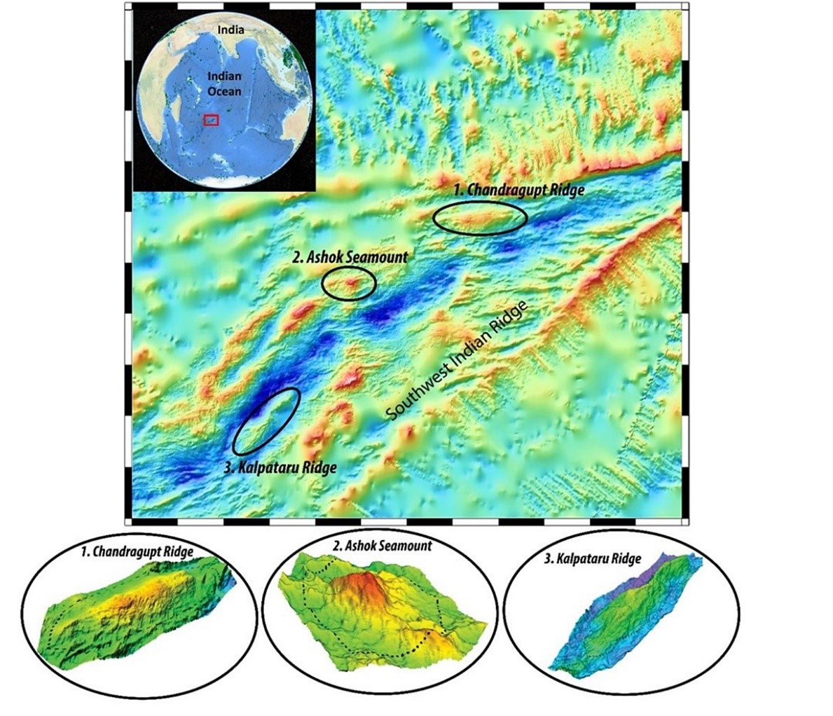
Naming of Undersea Feature
Why in news?
Recently, three underwater geographical structures located in the Indian Ocean have been awarded names proposed by India.
More about the news
These are named after the rulers of the Mauryan dynasty as the Ashoka seamount and the Chandragupt ridge. Kalpataru ridge is the third structure.
All the three recently named structures were discovered by oceanographers from the National Centre for Polar and Ocean Research (NCPOR), Goa.
These are located along the Southwest Indian Ridge area of the Indian Ocean and were discovered during an international survey exploration programme.
Since 2004, India has been undertaking the Indian Southern Ocean Research Programme with NCPOR being the nodal agency.
These sea explorations aim at studying the bio-geochemistry, biodiversity, lower atmospheric processes, paleoclimate, hydrodynamics, air-sea interactions among a host of other research areas.
.
Previously, other structures bearing Indian names include;
The Raman ridge (accepted in 1992), discovered in 1951 by a US oil vessel. It was named after Physicist and Nobel Laureate Sir CV Raman.
In 1992, the Panikkar Seamount (accepted in 1993) was discovered by India research vessel Sagar Kanya. It is named after NK Panikkar, a renowned oceanographer.
Deepest Rock Sample from Earth’s Mantle
Why in news?
Recently, scientists using the ocean drilling vessel JOIDES Resolution have penetrated 4,160 feet (1,268 meters) below the Atlantic seabed, reaching the deepest point ever in Earth's mantle rock.
More about the news
The samples obtained from the Atlantis Massif, an underwater mountain in the middle of the Atlantic Ocean, offer a glimpse into the upper mantle's interaction with seawater.
The Atlantis Massif, located near the mid-Atlantic Ridge, is one such site where mantle rock is exposed on the seafloor. Drilling was done under the International Ocean Discovery Program.
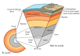
The mantle, which makes up more than 80% of Earth's volume, is a layer of silicate rock situated between the outer crust and the hot core. Typically, mantle rocks are inaccessible, except at seafloor spreading locations where tectonic plates diverge.
Preliminary analysis of the core sample has revealed a more extensive history of melting than expected, with the mineral orthopyroxene showing a wide range of abundance.
It is providing unprecedented insights into the composition and chemical processes of the mantle, Earth's most voluminous layer.
This discovery relates to the flow of melt through the upper mantle, which rises beneath spreading plates and migrates towards the surface to feed volcanoes.
The samples revealed how the mineral olivine had reacted with seawater at various temperatures.
This reaction releases hydrogen, forming compounds like methane that support microbial life, a key hypothesis for the origin of life on Earth.
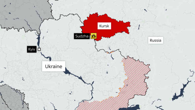
Kursk Region
Why in news?
Recently, Russia declared a federal-level emergency in the Kursk region after a significant incursion from Ukraine.
About Kursk Region
The Kursk Region is located in the central part of the Eastern European Plain and on the south-western border of Russia.
The Dnieper (Seim, Psel) and Don rivers flow through the region.
.
The area around Kursk was the site of a turning point in the Soviet–German struggle during World War II and the site of the single largest battle in history.
Russia’s Kursk region plays an important role in the gas supply chain.
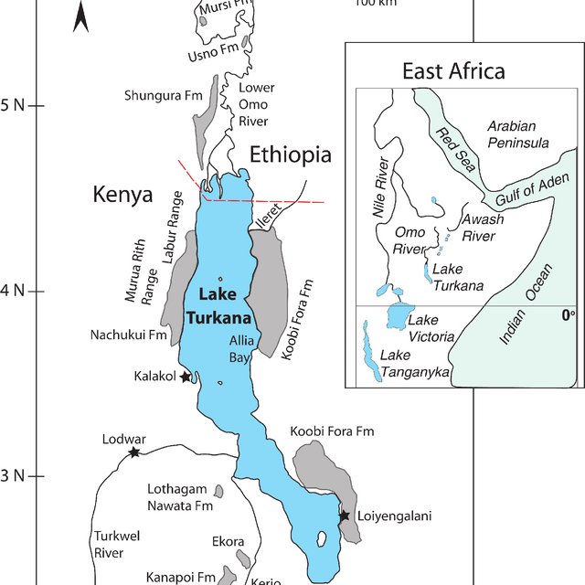
Lake Turkana
Why in news?
Recently, the first comprehensive survey of Lake Turkana was completed after 50 years.
Key Highlights of the survey
The initial findings from the 10-year research project led by UNESCO, revealed high fish potential in Africa's fourth-largest lake.
The potential of Lake Turkana's fishery resources remains largely untapped due to a lack of comprehensive understanding and the volatile nature of the lake.
About Lake Turkana
It is located in the remote northern region of Kenya.
Lake Turkana stands as Africa’s fourth-largest lake and the largest permanent desert lake in the world.
It is the world's largest permanent desert lake and the world's largest alkaline lake.
It lies in a hot, arid, and remote region, and provides resources for communities on the lakeshore and surrounding areas
This UNESCO World Heritage site is renowned for its unique biodiversity and cultural significance.
Military Exercise in news
Parvat Prahaar Exercise
The exercise is conducted by the Indian Army.
The 'Parvat Prahaar' (Mountain Strike) exercise emphasises mountainous and rugged terrains, such as those found in regions like Eastern Ladakh.
It is crucial for maintaining the readiness and effectiveness of the Army in the region, which is close to the India-China border.
Exercise Mitra Shakti
Mitra Shakti' is an annual event that alternates between India and Sri Lanka. The previous exercise was conducted in Pune, India, in November 2023.
The aim of the joint exercise is to enhance the joint military capability of both sides to undertake counter-insurgency operations in a sub-conventional scenario under Chapter VII of the United Nations Mandate.


 Profile
 Settings
 Refer your friends
 Sign out