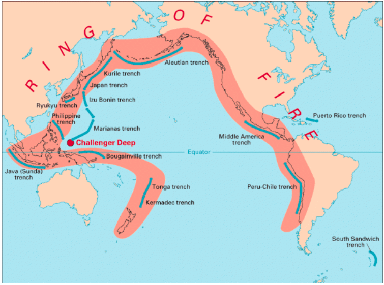
Taiwan is particularly prone to earthquakes as it lies along the Pacific “Ring of Fire” — where 90% of the world’s earthquakes take place.
About news
The island and its surrounding waters have registered about 2,000 earthquakes with a magnitude of 4.0 or greater since 1980, and more than 100 earthquakes with a magnitude above 5.5, according to the USGS.
What is the Ring of Fire?
The Ring of Fire is essentially a string of hundreds of volcanoes and earthquake-sites which runs along the Pacific Ocean.
It is a semicircle or horse shoe in shape and stretches nearly 40,250 kilometres.
The Ring of Fire traces the meeting points of numerous tectonic plates, including the Eurasian, North American, Juan de Fuca, Cocos, Caribbean, Nazca, Antarctic, Indian, Australian, Philippine, and other smaller plates, which all encircle the large Pacific Plate, according to a report by National Geographic.
It runs through 15 more countries including the USA, Indonesia, Mexico, Japan, Canada, Guatemala, Russia, Chile, Peru, and the Philippines.
Why is the Ring of Fire vulnerable to earthquakes?
The Ring of Fire witnesses so many earthquakes due to constant sliding past, colliding into, or moving above or below each other of the tectonic plates.
As the edges of these plates are quite rough, they get stuck with one another while the rest of the plate keeps moving.
An earthquake occurs when the plate has moved far enough and the edges unstick on one of the faults.
Taiwan experiences earthquakes due to the interactions of two tectonic plates — the Philippine Sea Plate and the Eurasian Plate.
Why are there so many volcanoes in the Ring of Fire?
The existence of volcanoes in the Ring of Fire is also due to the movement of tectonic plates.
Many of the volcanoes have been formed through a process known as subduction.
It takes place when two plates collide with each other and the heavier plate is shoved under another, creating a deep trench.
“Basically, when a ‘downgoing’ oceanic plate [like the Pacific Plate] is shoved into a hotter mantle plate, it heats up, volatile elements mix, and this produces the magma. The magma then rises up through the overlying plate and spurts out at the surface,” which leads to the formation of volcanoes, according to a report by DW.
Most of the subduction zones on the planet are located in the Ring of Fire and that’s why it hosts a large number of volcanoes.
Risk from glacial lake floods
Time to Read :🕑 11 Mins
Why in news?
To assess the risks posed by five potentially hazardous glacial lakes, the Uttarakhand government has formed two teams of experts. These lakes can trigger Glacial Lake Outburst Floods (GLOFs), which have caused several disasters in recent years in the Himalayan states.
More detail about news
TThe goal of the risk assessment exercise is to minimise the possibility of a GLOF incident and provide more time for relief and evacuation in case of a breach.
The National Disaster Management Authority (NDMA), which operates under the Union Ministry of Home Affairs, has identified 188 glacial lakes in the Himalayan states that can potentially be breached because of heavy rainfall. Thirteen of them are in Uttarakhand.
Rising surface temperatures across the globe, including India, have increased the risk of GLOFs.
Studies have shown that around 15 million people face the risk of sudden and deadly flooding from glacial lakes, which are expanding and rising in numbers due to global warming.
What are GLOFs?
GLOFs are disaster events caused by the abrupt discharge of water from glacial lakes — large bodies of water that sit in front of, on top of, or beneath a melting glacier.
As a glacier withdraws, it leaves behind a depression that gets filled with meltwater, thereby forming a lake.
The more the glacier recedes, the bigger and more dangerous the lake becomes. Such lakes are mostly dammed by unstable ice or sediment composed of loose rock and debris. In case the boundary around them breaks, huge amounts of water rush down the side of the mountains, which could cause flooding in the downstream areas — this is referred to as a GLOF event.
Causes of GLOFs
GLOFs can be triggered by various reasons, including glacial calving, where sizable ice chunks detach from the glacier into the lake, inducing sudden water displacement. Incidents such as avalanches or landslides can also impact the stability of the boundary around a glacial lake, leading to its failure, and the rapid discharge of water.
Impacts
GLOFs can unleash large volumes of water, sediment, and debris downstream with formidable force and velocity.
The floodwaters can submerge valleys, obliterate infrastructure such as roads, bridges, and buildings, and result in significant loss of life and livelihoods.
Why are GLOFs under the spotlight?
In recent years, there has been a rise in GLOF events in the Himalayan region as soaring global temperatures have increased glacier melting.
Rapid infrastructure development in vulnerable areas has also contributed to the spike in such incidents.
Since 1980, in the Himalayan region, particularly in southeastern Tibet and the China-Nepal border area, GLOFs have become more frequent, according to a study, ‘Enhanced Glacial Lake Activity Threatens Numerous Communities and Infrastructure in the Third Pole’, published in the journal Nature in 2023.
The analysis was done by Taigang Zhang, Weicai Wang, Baosheng An and Lele Wei — all from the Institute of Tibetan Plateau Research in China.
“Approximately 6,353 sq km of land could be at risk from potential GLOFs, posing threats to 55,808 buildings, 105 hydropower projects, 194 sq km of farmland, 5,005 km of roads, and 4,038 bridges in the region,” according to the study.
Another analysis, ‘Glacial Lake Outburst Floods Threaten Millions Globally’, published in the journal Nature in February 2023, showed that about 3 million people in India and 2 million in Pakistan face the risk of GLOFs.
This study was conducted by Caroline Taylor, Rachel Carr and Stuart Dunning of Newcastle University, the United Kingdom, Tom Robinson of the University of Canterbury, New Zealand, and Matthew Westoby of Northumbria University, the UK.
“While the number and size of glacial lakes in these areas (India and Pakistan) isn’t as large as in places like the Pacific Northwest or Tibet, it’s that extremely large population and the fact that they are highly vulnerable that mean Pakistan and India have some of the highest GLOF danger globally,” Tom Robinson, co-author of the study and lecturer in Disaster Risk & Resilience at the University of Canterbury, told The Indian Express in February last year.
What is the situation in Uttarakhand?
Uttarakhand has witnessed two major GLOF events in the past few years.
The first took place in June 2013, which affected large parts of the state — Kedarnath valley was the worst hit, where thousands of people died.
The second occurred in February 2021, when Chamoli district was hit by flash floods due to the bursting of a glacier lake.
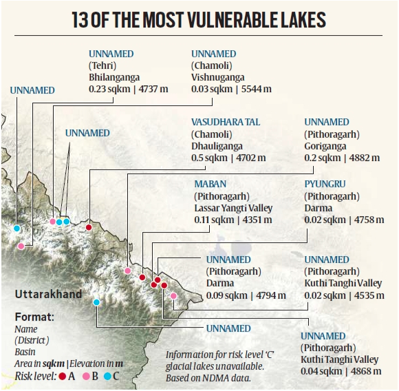
As mentioned earlier, Uttarakhand has 13 glacial lakes which are prone to GLOF. Based on the analysis of available data and research from various technical institutions, these lakes have been categorised into three risk levels: ‘A’, ‘B’, and ‘C’.
Five highly sensitive glacial lakes fall into the ‘A’ category.
These include Vasudhara Tal in the Dhauliganga basin in Chamoli district, and four lakes in Pithoragarh district — Maban Lake in Lassar Yangti Valley, Pyungru Lake in the Darma basin, an unclassified lake in the Darma basin, and another unclassified lake in Kuthi Yangti Valley.
The areas of these five lakes range between 0.02 to 0.50 sq km, and they are situated at elevations ranging from 4,351 metres to 4,868 metres.
The rising surface temperatures could worsen the situation in Uttarakhand.
The hill annual average maximum temperature may increase by 1.6-1.9 degree Celsius between 2021-2050, according to a 2021 study, ‘Locked Houses, Fallow Lands: Climate Change and Migration in Uttarakhand, India’, carried out by the Germany-based Potsdam Institute for Climate Research (PIK) and The Energy and Resources Institute (TERI) in New Delhi. This could exacerbate the risk of GLOFs in the state.
First commercial crude storage
Time to Read :🕑 5 Mins
Why in news?
India, the world's third-largest oil consumer and importer, is planning to build its first commercial crude oil strategic storage facility. This move aims to bolster its stockpiles and serve as insurance against potential supply disruptions.
About
Indian Strategic Petroleum Reserves Ltd (ISPRL), a special purpose vehicle created by the government for building and operating strategic petroleum reserves in the country, has invited bids for constructing 2.5 million tonnes of underground storage at Padur in Karnataka, according to the tender document.
ISPRL had in the first phase built a strategic petroleum reserve in underground unlined rock caverns for storage of 5.33 million tonnes of crude oil at three locations Visakhapatnam (1.33 million tonnes) in Andhra Pradesh and Mangalore (1.5 million tonnes) and Padur (2.5 million tonnes) in Karnataka.
Under Phase-II, it intends to build a commercial cum strategic petroleum reserve in underground unlined rock caverns along with associated above ground facilities, including dedicated SPM and associated pipelines (offshore and onshore) for storage of 2.5 million tonnes of crude oil at Padur-II at a cost of ₹5,514 crore.
The Phase-I storages were built at government expense.
In the tender, ISPRL said the Padur-II will be constructed in a PPP (public-private partnership) model where private parties will design, build, finance, and operate the storage.
The Civil Services Exam is conducted every year by the UPSC to select suitable candidates for the Indian Administrative Service (IAS), IFS (Indian Foreign Service), IPS (Indian Police Service), IRS (Indian Revenue Service) and other Central Services like the Audits and Accounts, Railway Technical Services etc.
These services are vital for the administration of the Nation as they form the underlying basis of the policy formulation, implementation and execution in almost all the domains of the Governance. Sardar Patel had called the Civil Service the “Steel Frame of India“, the backbone of India’s Administration.
Being part of the Services is associated with prestige, power and a sense of responsibility toward the Society and the Nation. No doubt, the Services attract the best among the vast talent pool of the country.
And it is no surprise that the competition for the CSE is becoming fiercer every year. Over the last 3-4 years the number of applicants has hovered around 1,000,000 out of which approximately 500,000 appear for the Preliminary Exam. On an average 10,000 candidates qualify for the Mains Examination and less than 2,500 are called for the interview. Finally, only about 1,000 or fewer candidates qualify to be part of the Services. Thus the conversion ratio from appearing in the Preliminary Examination to the final selection in the Services is less than 0.2% (considering only the
Thus only sincere hard work may not be enough to be part of the Services. The aspirants need suitable guidance and study material to get selected and fulfil their dream of serving the Nation. Unacademy strives to provide quality content to the learners in order to supplement the guidance they receive from top Educators on the Unacademy Platform and aid their preparation.


 Profile
 Settings
 Refer your friends
 Sign out