 Profile
 Settings
 Refer your friends
 Sign out


Alluvial Fans:
- These are formed when streams flow from a height and the pressure bursts the plains on the slopes of the lower gradient feet.
- A rough load is usually carried by the stream that flows down from the mountain slopes. This load is so heavy that the stream can be carried over soft gradients as well as it can discard and distribute a wide deposit-shaped cone called an alluvial fan.
- Streams and Fans are not limited to their actual channels for a long time, also they change their stance on their followers and never retreat to the mainstream after leaving its main channel. They are usually known as distributaries.
- Alluvial fans in humid areas often show low lumps with a slight slope from head to toe, and in dry and desert areas appear as high sloping lumps.
Deltas:
- Delta is similar to alluvial fan but it develops in a different area.
- River cargo is dumped and distributed in the sea. If this sediment is not carried away far from the sea or equally distributed along the coast, it spreads and accumulates similar to a low cone.
- Unlike the alluvial fans, deposits are very well organized with clear stratification.
- Rough objects come out first and the other fine pieces such as mud and clay are thrown into the sea.
- As the delta grows, the river continues to increase in length and the delta continues to overflow into the sea.
Flood plains:
- The Floodplain is a large area for river formation. First, large objects are inserted while the broadcast channel leaves the slope. It is composed of unconsolidated sedimentary deposits (alluvium) and subjected to periodic inundation by the stream
- Fine materials such as sand and mud are carried slowly through the soft trenches that are usually found on the plains and are placed on the bed where water spills over it on the shore during floods.
- Floodplain consists of two types of deposits: Flood deposits and Channel deposits. Floodplains do not work over banks.
- On the plains, the channels flow sideways and change their courses timely while leaving the limited courses gradually filling up. The flooded areas formed by unpaved or cut-off tunnels contain wage deposits.
- Spills of water carry fine materials such as mud and clay.
- Side floods are known as Delta plains.
Natural Levees and Point Bars:
- These are flooded areas.
- Natural Levees are found on the banks of large rivers. They are low, linear, and cohesive.
- Point bars are also known as Meander bars. They are found on the valleys of major rivers and remain arranged in a line of water cascading down the coast. They are almost identical in profile and width and contain a variety of mixed sizes.
Meanders:
- Rivers rarely flow in a straight line in delta and floodplains. Due to this meanders grow over flood and delta plains. Meanders are loop-shaped water patterns.
- The reason behind the channel pattern:
Tendency of water to flow over soft gradients to pass along the shores.
Incorporated environment of alluvial deposits forms banks with multiple defects that can be used by water for piping.
Coriolis energy works in liquids that divert them as if diverting air.
- Small curves are formed due to irregular banks.
- This curve deepens because of the deposition in the inner part of the curve and erosion in the outer side of the bank.
- With no space and zero erosion or cutting, the tendency to roam decreases.
- In the tunnels of major rivers, there is an active area near the edge of the cave and across the bottom of the convex bank.
The concave bank is known as the Cut-off bank which appears to be steep.
Convex banks have a long and gentle profile.
Meanders grow into deeper traps. However, they may be damaged due to erosion in dynamic areas and could be left as ox-bow pools.
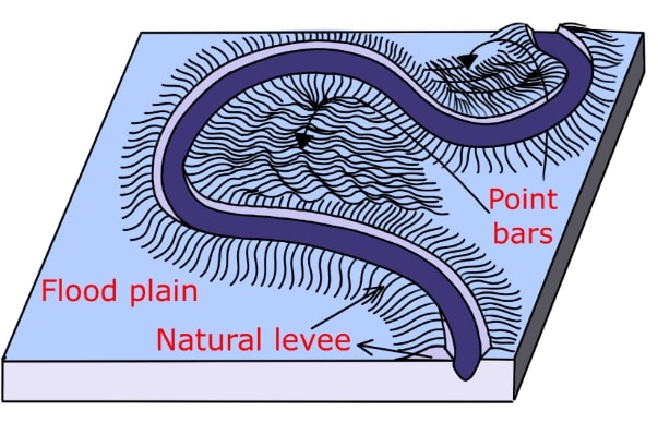
Fig: Natural Levees and Point Bars:
Natural Levees and Point Bars:
- These are flooded areas.
- Natural Levees are found on the banks of large rivers. They are low, linear, and cohesive.
- Point bars are also known as Meander bars. They are found in the valleys of major rivers and remain arranged in a line of water cascading down the coast. They are almost identical in profile and width and contain a variety of mixed sizes.
Meanders:
- Rivers rarely flow in a straight line in delta and flood plains, due to this meanders grow over flood and delta plains
- Meanders are loop-shaped water patterns
- The reason behind the channel pattern: 1. 1. Tendency of water to flow over soft gradients to pass along the shores.
2. Incorporated environment of alluvial deposits forms banks with multiple defects that can be used by water for piping.
3. Coriolis energy works in liquids that divert them as if diverting air.
- Small curves are formed due to irregular banks
- This curve deepens because of the deposition in the inner part of the curve and erosion in the outer side of the ban
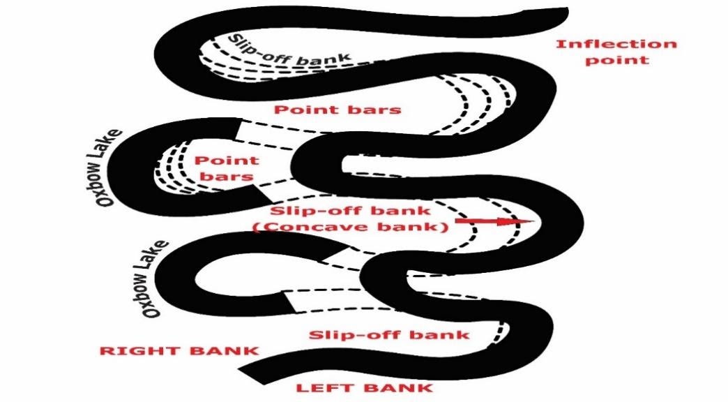
Fig: Meander growth and cut-off loops and Slip-off and undercut banks
- With no space and zero erosion or cutting, the tendency to roam decreases.
- In the tunnels of major rivers, there is an active area near the edge of the cave and across the bottom of the convex bank.
Ø The concave bank is known as the Cut-off bank which appears to be steep.
Ø Convex banks have a long and gentle profile.
- Meanders grow into deeper traps. However, they may be damaged due to erosion in dynamic areas and could be left as ox-bow pools.
