Q.1 – If a major solar storm (solar flare) reaches the Earth, which of the following are the possible effects on the Earth ?
1. GPS and navigation systems could fail.
2. Tsunamis could occur at equatorial regions.
3. Power grids could be damaged.
4. Intense auroras could occur over much of the Earth.
5. Forest fires could take place over much of the planet.
6. Orbits of the satellites could be disturbed.
7. Shortwave radio communication of the aircraft flying over polar regions could be interrupted.
Select the correct answer using the code given below :
(a) 1, 2, 4 and 5 only
(b) 2, 3, 5, 6 and 7 only
(c) 1, 3, 4, 6 and 7 only
(d) 1, 2, 3, 4, 5, 6 and 7
Option (c) is correct: A solar flare is an intense burst of radiation coming from the release of magnetic energy associated with sunspots.
The explosive heat of a solar flare can’t make it all the way to our globe (Hence Statement 5 can be said wrong), but electromagnetic radiation and energetic particles certainly can. Solar flares can temporarily alter the upper atmosphere creating disruptions with signal transmission from, say, a GPS satellite to Earth causing it to be off by many yards. Another phenomenon produced by the sun could be even more disruptive. Known as a coronal mass ejection or CME these solar explosions propel bursts of particles and electromagnetic fluctuations into Earth’s atmosphere. Those fluctuations could induce electric fluctuations at ground level that could blow out transformers in power grids. A CME’s particles can also collide with crucial electronics onboard a satellite and disrupt its systems. (Source NASA website).
Tsunami is a long, high sea wave caused by an earthquake or the oceanic volacno activity. Similary forest fire can not be caused directly by solar flares as they are not too much powerfull to burn earth surface.
Q.2 – Which one of the following lakes of West Africa has become dry and turned into a desert ?
(a) Lake Victoria
(b) Lake Faguibine
(c) Lake Oguta
(d) Lake Volta
Option (b) is correct: The Lake Faguibine System, four interlinked lakes 80 km west of Timbuktu, was historically one of Mali’s most fertile areas. But over seven years, droughts in the 1970s dried up the lakes.
Then sand filled the channels connecting the lakes to the River Niger, with the result that when rain finally returned the water could no longer reach the lakes. The region’s prosperity evaporated along with the water.
In the past, during prolonged rainfall in the Fouta Djallon highlands in Guinea, the river flooded and forced water to flow through two channels into the lake.
Q.3 – Gandikota canyon of South India was created by which one of the following rivers ?
(a) Cauvery
(b) Manjira
(c) Pennar
(d) Tungabhadra
Option (c) is correct: Gandikota Canon is situated on the Pennar River in Andhra Pradesh and is known as the Grand Canyon of India. It is formed between the Erramala range of hills which are also known as Gandikota hills. The river Pennar that flows at its foot and the area is marked by deep valleys and massive boulders of granite
A gorge is a narrow valley between hills or mountains, typically with steep rocky walls and a stream running through it. Gorges are formed because of rock erosion over a long period of time.
Q.4 – Consider the following pairs :
Peak Mountains
1.Namcha Barwa — Garhwal Himalaya
2. Nanda Devi — Kumaon Himalaya
3. Nokrek — Sikkim Himalaya
Which of the pairs given above is/are correctly matched ?
(a) 1 and 2
(b) 2 only
(c) 1 and 3
(d) 3 only
Option (b) is correct:
Pair 1 is not correct: Assam Himalayas, eastern section of the Great Himalayas, extending eastward across Sikkim state (India) and Bhutan, into northern Assam and Arunachal Pradesh states (India), and along the border with the Tibet Autonomous Region (China). Important peaks include Kula, Chomo, and Kangto; the highest is Namjagbarwa (Namcha Barwa; 25,445 feet [7,756 metres]) in Tibet.
Pair 2 is correct: Kumaun Himalayas, west-central section of the Himalayas in northern India. The range, comprising part of the Siwalik Range in the south and part of the Great Himalayas in the north, lies largely within the state of Uttarakhand, northwest of Nepal. It rises to 25,646 feet (7,817 metres) at Nanda Devi, the range’s highest peak, and to 25,446 feet (7,756 metres) at Kamet, near the Chinese border.
Pair 3 is not correct: The Nokrek is the highest peak of the Garo hills, rising up 1,412 metres. which forms part of the Meghalaya Plateau.
Q.5 – The term “Levant” often heard in the news roughly corresponds to which of the following regions ?
(a) Region along the eastern Mediterranean shores
(b) Region along North African shores stretching from Egypt to Morocco
(c) Region along Persian Gulf and Horn of Africa
(d) The entire coastal areas of Mediterranean Sea
Option (a) is correct: From the beginning of civilization, the Levant, the coastal region of the eastern Mediterranean from Syria in the north to Egypt in the south, was the crossroads of various peoples and cultures. From this important trade region, fundamental social and economic changes began spreading across the Middle East and the Mediterranean, leaving behind a rich heritage of unique material remains.
Q.6 – Consider the following countries :
1. Azerbaijan
2. Kyrgyzstan
3. Tajikistan
4. Turkmenistan
5. Uzbekistan
Which of the above have borders with Afghanistan ?
(a) 1, 2 and 5 only
(b) 1, 2, 3 and 4 only
(c) 3, 4 and 5 only
(d) 1, 2, 3, 4 and 5
Option (c) is correct: Afghanistan shares borders with Iran, Pakistan, Turkmenistan, Tajikistan, Uzbekistan, China and India.
Q.7 – With reference to India, consider the following statements :
1. Monazite is a source of rare earths.
2. Monazite contains thorium.
3. Monazite occurs naturally in the entire Indian coastal sands in India.
4. In India, Government bodies only
can process or export monazite.
Which of the statements given above are correct ?
(a) 1, 2 and 3 only
(b) 1, 2 and 4 only
(c) 3 and 4 only
(d) 1, 2, 3 and 4
Option (b) is correct:
Statement 1 is correct: Monazite in general, contains about 55 – 60% total Rare Earth Oxide.
Statement 2 is correct: Monazite is a mineral mainly containing rare earths and thorium-a prescribed substance to be handled by the Department of Atomic Energy (DAE).
Statement 3 is incorrect: Monazite doesn’t occurs naturally in the entire Indian coastal sands in India.
Statement 4 is correct: A licence from the Department of Atomic Energy (DAE) under the Atomic Energy (Working of the Mines. Minerals and Handling of Prescribed Substances) Rules 1984 promulgated under the Atomic Energy Act 1962 is necessary for exporting monazite.
Indian Rare Earths Limited (IREL), a wholly owned Public Sector Undertaking of the Government of India (GOI) under DAE, is the only entity which has been permitted to produce and process monazite, and handle it for domestic use as well as for export.
Q.8 – In the northern hemisphere, the longest day of the year normally occurs in the :
(a) First half of the month of June
(b) Second half of the month of June
(c) First half of the month of July
(d) Second half of the month of July
Option (b) is correct: Since a large portion of the Northern Hemisphere is getting light from the sun, it is summer in the regions north of the equator. The longest day and the shortest night at these places occur on 21st June (i.e. second half of the month of June). At this time in the Southern Hemisphere all these conditions are reversed. It is winter season there. The nights are longer than the days. This position of the earth is called the Summer Solstice
Q.9 – Consider the following pairs :
Wetland/Lake Location
1. Hokera Wetland — Punjab
2. Renuka Wetland — Himachal Pradesh
3. Rudrasagar Lake — Tripura
4. Sasthamkotta Lake — Tamil Nadu
How many pairs given above are correctly matched ?
(a) Only one pair
(b) Only two pairs
(c) Only three pairs
(d) All four pairs
Option B is correct:
Only 2 pairs are correctly matched.
1. HOKERA WETLAND: JAMMU AND KASHMIR
2. RENUKA WETLAND: HIMACHAL PRADESH
3. RUDRASAGAR LAKE-: TRIPURA
4. SASTHAMKOTTA LAKE: KERALA
Q.10 – Consider the following statements :
1. High clouds primarily reflect solar radiation and cool the surface of the Earth.
2. Low clouds have a high absorption of infrared radiation emanating from the Earth’s surface and thus cause warming effect.
Which of the statements given above is/are correct ?
(a) 1 only
(b) 2 only
(c) Both 1 and 2
(d) Neither 1 nor 2
Option (d) is correct:
● Statement 1 is incorrect: High clouds are often thin and do not reflect very much. They let lots of the Sun’s warmth in. They radiate less energy into space than the lower, warmer clouds. Therefore, high clouds work to “trap” more energy than the low clouds.
● Statement 2 is incorrect: Low clouds are often quite thick and reflect lots of sunlight back to space. Low clouds are excellent reflectors. But, they don’t stop the longwave energy from escaping to space. Therefore, low clouds help to cool the Earth.
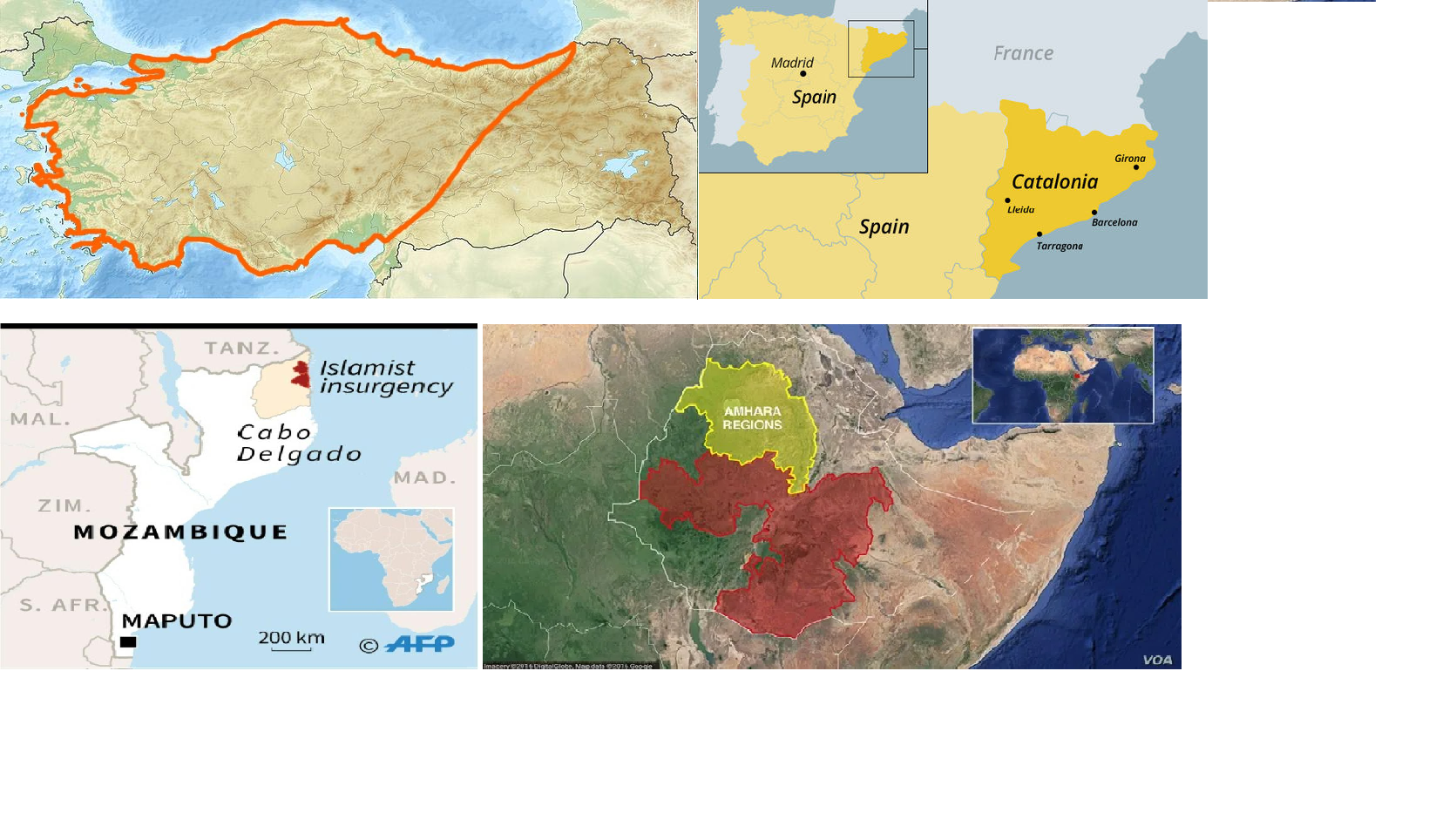
Q.11 – Consider the following pairs :
Region often mentioned in the news – Country
1. Anatolia — Turkey
2. Amhara — Ethiopia
3. Cabo Delgado — Spain
4. Catalonia — Italy
How many pairs given above are correctly matched ?
(a) Only one pair
(b) Only two pairs
(c) Only three pairs
(d) All four pairs
Option (d) is correct:
1. Anatolia—Turkey (pair 1 is correctly matched)
2. Amhara—Ethiopia (pair 2 is correctly matched)
3. Cabo Delgado—Mozambique (pair 3 is not correctly matched)
4. Catalonia—Spain (pair 4 is not correctly matched)
1. Andhra Pradesh
2. Kerala
3. Himachal Pradesh
4. Tripura
How many of the above are generally known as tea-producing States ?
(a) Only one State
(b) Only two States
(c) Only three States
(d) All four States
Tea cultivation is an example of plantation agriculture. It is also an important beverage crop introduced in India initially by the British. The tea plant grows
well in tropical and sub-tropical climates endowed with deep and fertile well-drained soil, rich in humus and organic matter.
Option (d) is correct: Major tea producing states are Assam, hills of Darjeeling and Jalpaiguri districts,
West Bengal, Tamil Nadu and Kerala.
Apart from these, Himachal Pradesh, Uttarakhand, Meghalaya, Andhra Pradesh and
Tripura are also tea-producing states in the country. (Source- NCERT Class 10 Contemporary India, Chapter 4 Agriculture, page-41)
Q.13 – Consider the following pairs :
Reservoirs – States
1. Ghataprabha — Telangana
2. Gandhi Sagar — Madhya Pradesh
3. Indira Sagar — Andhra Pradesh
4. Maithon —Chhattisgarh
How many pairs given above are not correctly matched ?
(a) Only one pair
(b) Only two pairs
(c) Only three pairs
(d) All four pairs
Option (c) is correct: Ghatprabha- Karnataka (Pair 1 is not correctly matched)
Gandhi Sagar- Madhya Pradesh (Pair 2 is correctly matched)
Indira Sagar- Madhya Pradesh (there is one irrigation projet with the similar name in Andhra as the ‘Indirasagarpolavaram-project’ commonly known as the Polavaram Irrigation Project) (Pair 3 is not correctly matched)
Maithon- Jharkhand (Pair 4 is not correctly matched)
The Gandhi Sagar Dam is built on India’s Chambal River. The dam is located in the Mandsaur district, Madhya Pradesh.
The Maithon Dam is located at Maithon, 48 km from Dhanbad, in the state of Jharkhand. It is located on the banks of Barakar River. The Barakar River is the tributary of the Damodar River.
Additional Information: Polavaram Irrigation Project (Andhra Pradesh) is located on river Godavari in West Godavari district of Andhra Pradesh. The project is multipurpose major terminal reservoir project on river Godavari for development of Irrigation, Hydro power and drinking water facilities to East Godavari, Vishakhapatnam, West Godavari and Krishna districts of Andhra Pradesh.
 Profile
 Settings
 Refer your friends
 Sign out


