 Profile
 Settings
 Refer your friends
 Sign out


From the surface of Earth, geostationary orbits can be seen for twenty-four hours. Due to its fixed position, the geostationary orbit can document and record significant Earth from its constant position. A geostationary satellite will always seem to be stationary to Earth.
Geostationary satellite period = Earth’s period of rotation.
The period of geostationary orbit, t = 24 hours.
In altitude, the geostationary orbit is above Earth’s equator. In Inradius, the GEO is forty-two thousand kilometres from Earth’s centre as it follows Earth’s rotation. Satellites are placed in the geostationary orbit. Satellites are placed in a fixed orbit to avoid rotation as it’s easier to pinpoint them in the sky. Tracking them from satellite antennas located on land becomes uncomplicated.
Different types of Satellite
Some Geostationary satellite examples are:
Communication Satellite
The second kind of Satellite placed in the geostationary orbit is the weather satellite. Weather satellites provide us with real-time weather monitoring and evaluation of data. With the help of weather satellites, we receive daily reports of weather on Earth.
The third kind of satellite found in geostationary orbit is the navigation satellite. These satellites provide a known calibration point and help in enhancing the accuracy of GPS. Without navigation satellites, google maps would be impossible to use.
Geostationary Orbit formula
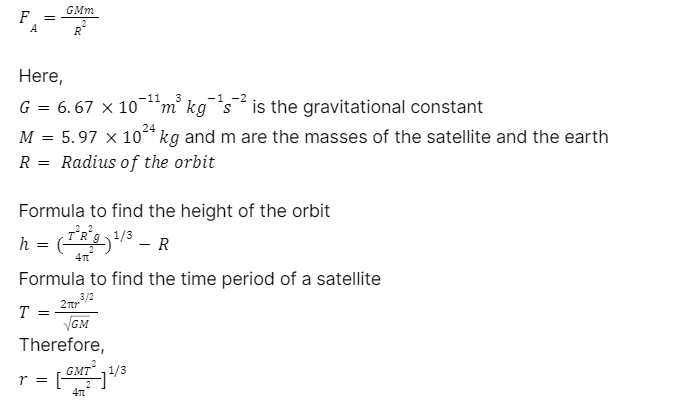
The gravitational force FA between the satellite and the earth is in the inner portion of the radial direction, and the equation gives the magnitude.
Uses of Geostationary Satellite
Geostationary orbits are utilised for different forms of telecommunication, such as television. The signals received and sent from these can be anywhere and worldwide. Geostationary satellite imaging ability has been utilised to monitor volcanic ash, take the measurement of clouds, calculate the temperature, and compute water vapour.
The satellite can be used for oceanography, evaluating the temperature of the land, covering the area of vegetation and predicting the path of cyclones and bringing forth actual-time data available at fingertips.
These antennas can be fixed in place and are much less expensive than tracking antennas. These satellites have revolutionised global communications, television broadcasting and weather forecasting and have several important defence and intelligence applications.
The antennas for geostationary orbits are fixed in one place, making them less costly than antennas used for tracking. The use of satellites has transformed and brought about significant changes such as worldwide communication, television broadcasting and weather predicting.
Most economical, commercialised and broadcasting satellite function in geostationary orbits.
Communication
Present in the geostationary orbit, the communication satellites are convenient due to their visibility from a vast area of Earth’s surface, expanding eighty-one degrees in both the latitude and longitude.
As the satellites present in the geostationary orbits are stationary, this feature removes the need for land satellite stations having variable antennas. The elaborate meaning of this is that Earth-based spectators can put up small, less expensive and stationary antennas straight forward directly at the required Satellite. The amount of latency significantly goes up as the signal travels 240ms from the land stations to the satellite.
This latency comes as a disadvantage in voice communication, creating speech and action delays. Thus, the communication satellites are mainly used for one-directional entertainment and application where the latency delay does not affect the quality.
The geostationary satellites are present just overhead at the equator and seem lower in the sky to a watcher standing close to the poles. As the latitude of watchers expands, the distance increases, causing the communication to become tough. Certain factors include:
- Atmospheric refraction.
- Thermal emission of Earth.
- Line of sight obstacles.
- Backscattering of signals from the land or nearby landmarks.
Above the essential eight one degree latitude, geostationary satellites are found beneath the horizon and are not visible. Due to this reason, Russia has used Molniya and Tundra Orbits for communication satellites which offer significant quality even at a latitude above 81°
Meteorology
In the geostationary orbits, many functioning geostationary meteorological satellites are present. These satellites give visible and infrared pictures of Earth’s surface and atmosphere for observing weather, oceanography, and tracking of the atmosphere.
The meteorological satellite takes pictures in the visible and infrared spectrum. The spatial resolution falls between 0.5-4.0 sq. km.
Although data has been added to meteorological prediction models, geostationary weather satellites pictures are mostly utilised for brief and actual time forecasting because of the vast area of view, continuous monitoring, observation, and low resolution.
Conclusion
A geostationary satellite is a satellite that revolves from West to East with a period of revolution equal to 24 hours in a circular orbit, concentric and coplanar with the equator of the Earth.
The use of geostationary orbits is determined by two types of Satellite found in orbit:
- Communication Satellite
- Meteorological Satellite
These satellites offer a wide array of uses, such as Imaging for tracking volcanic ash and evaluating the temperature of cloud top and water vapour, oceanography, calculating land temperature and vegetation coverage, cyclone path prediction, studying the radiation of cosmic rays and providing real-time cloud coverage and other tracking data.
