 Profile
 Settings
 Refer your friends
 Sign out


Understanding Satellite Maps:
- Night Microphysics: The INSAT 3D satellite uses a red-green-blue (RGB) imager. The colors in its images are determined by solar reflectance and brightness temperature.
- Color Determination: Two colors are determined by the difference between two signals, while the blue color is determined by the strength of a thermal infrared signal of wavelength 10.8 micrometer.
Solar Reflectance: This is the ratio of solar energy reflected by a surface to the solar energy incident on it. Brightness Temperature: This relates to the temperature of an object and the corresponding brightness of its surface, differing from the temperature we feel. |
Applications:
- Weather Event Tracking: By combining day and night microphysics data, scientists can track the formation, evolution, and depletion of cyclones and other weather events.
- Thunderstorm Prediction: The satellites can produce images indicating impending thunderstorms.
Satellite Data Collection:
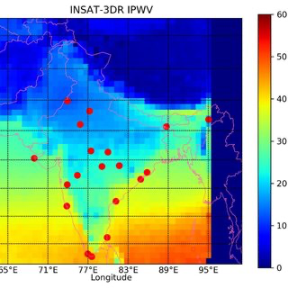
- Radiometres: Both INSAT 3D and INSAT 3DR use radiometres to measure properties of radiation.
- Atmospheric Sounders: These devices measure temperature, humidity, and study water vapor at different heights.
India’s Weather Satellites:
- Evolution: From Kalpana 1 and INSAT 3A to INSAT 3D and 3DR, each satellite has been an upgrade in terms of technology and capabilities.
- Current Satellites: INSAT 3D and 3DR are active in geostationary orbits, providing crucial data for weather monitoring.
Why in News:
- North India, including regions like Bihar, Uttar Pradesh, Uttarakhand, Haryana, Delhi, and Punjab, has experienced heavy fog since December 2023. The IMD has been using maps from the INSAT 3D and INSAT 3DR satellites to track and illustrate these weather patterns.